导航
| 速度限制 |
Y |
| 轨道数量 |
200 |
| 航线数量 |
200 |
| 交通信息频道(TMC) |
Y |
| 车道控制引导 |
Y |
其他功能
| GPS接收机 |
SIRF III |
| 基本图 |
Y |
| 接口 |
mini USB |
| 内置存储器 |
4096 MB |
GPS类型
| 自动 |
Y |
| 体育(健身,跑 步,骑自行车) |
N |
| 户外(登山,远足) |
N |
| 海洋(图绘图仪,探测器,测距仪鱼) |
N |
| 地理寻宝 (gps寻宝) |
N |
| 航空 |
N |
Boasting a new Skin Touch design, the Becker Traffic Assist Z 203 impresses with innovative features and additional functionality, including a 4.3 inch touch screen, automotive quality hands-free capability, optimised route guidance and customisable configuration.
Thanks to NAVTEQ Traffic Patterns, accumulated traffic data are included in route calculations, enabling the device to determine optimal routes according to the day of the week and time of day. This means time and cost savings, and above all, a relaxing drive – because excessively used stretches are simply avoided.
With map data for 42 countries preinstalled on the 4 GB internal flash memory, more POIs and alternative petrol stations, camping and caravan sites, 3D town and terrain view, as well as the ability to install additional features, car travel is now even more convenient and adventure-inspiring.
*Dynamic route guidance with TMC Austria, Belgium, Denmark, Germany, the Netherlands, Spain, Sweden and Switzerland. Access to TMC information without active route guidance. When traffic jam avoidance is possible, an alternative route is displayed for selection.
NAVTEQ TRAFFIC PATTERNS
Accumulated traffic data are included in route calculations, enabling the device to determine optimal routes according to the day of the week and time of day. Frequently jammed roads and junctions are thereby avoided.
TMC*
With TMC (Traffic Message Channel), the latest traffic information can be accessed in the selected broadcasting area at any time. The navigation unit automatically detects the current traffic situation and recalculates the route on request. Dynamic route guidance helps avoid unnecessary delays.
3D TOWN VIEW
While driving through towns and cities, buildings and streets of houses are represented in 3D along your route, showing you in Map View the scenery you are currently driving past. This presentation of buildings along the route makes orientation easier in urban settings.
3D TERRAIN VIEW
During your journey, the landscape you are driving through will be displayed in 3D. This provides prior notice of approaching ascents and descents or winding roads, allowing you to prepare for on-coming driving demands.
BLUETOOTH® WIRELESS TECHNOLOGY
The Bluetooth® interface is designed for connecting Bluetooth®-compatible mobile phones. Telephone numbers and addresses can be directly entered via the touch-screen display or selected from a list of contacts.
TEXT-TO-SPEECH
During your journey, the announcement of street names will be integrated into spoken navigation instructions. This enhancement makes orientation and turning procedures even easier.
TRAFFIC SIGN DISPLAY
While driving on motorways in Europe, traffic signs with place names and directional indicators are dynamically displayed. This feature particularly eases orientation during frequent motorway transfers and at motorway junctions.
CONTENT MANAGER
Using the Content Manager software on your PC, you can customise the configuration of your device, transferring for example preferred map data, voice and game settings directly to the navigation system.
GPS NAVIGATION
The Global Positioning System (GPS) is a satellite-based navigation system developed by the United States Department of Defence. GPS signals accurately determine the position of a receiver within a few metres. Independent of the means of transport, the signal information is continuously scanned to precisely calculate routes and arrival times.
POINTS OF INTEREST
The map data for Europe contains special destinations including airports, hospitals, service stations, hotels, restaurants and stadiums. Miniature icons show points of interest along the selected route.
MOBILE NAVIGATION
Mobile navigation units are easy to install in just a few steps and can be used practically anywhere. A perfect travel companion for added safety and convenience in the car, on a bike or motorcycle.
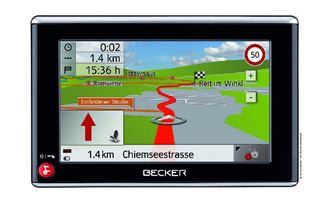
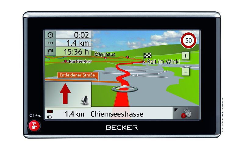
LANE INFO
The Lane Info function points the way on multi-lane roads and complicated motorway exits. This gives the driver enough time to change lanes as required.
TOUCH SCREEN
All menu items are quick and easy to access via the 4-inch touch-screen display.
MINI-USB PORT
Software updates and downloads may be directly transferred from a PC to the navigation device via the Mini-USB port. The Mini-USB cable also allows charging the device’s batteries from a PC or notebook.
SPEED LIMITS
A graphic image of the current speed limit appears in the display. An acoustic signal warns the driver when the preset level has been exceeded.
DAY/NIGHT MODE
The display brightness can be easily adjusted from day to night mode via the "Settings" menu. This feature ensures optimal readability in changing light conditions, for example, when driving through a long tunnel.