产品特点
| 区域定位 |
North America |
| 国家覆盖 |
USA |
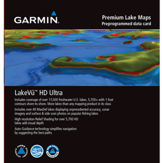
U.S. LakeVü HD Ultra
The Ultimate Freshwater Fishing Map
- Includes 99 MaxDef lakes showing a level of detail unprecedented in Garmin maps
- Auto Guidance shows the best path to a destination. Use in conjunction with Satellite imagery to provide enhanced situational awareness
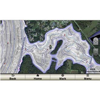
- High-resolution Relief Shading adds visual depth
- Dynamic Lake Level setting adjusts maps based on current water levels
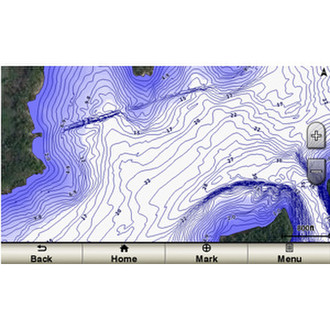
- Depth Range Shading for up to 10 ranges enable you to view your target depth at a glance
The ultimate freshwater fishing map, LakeVü HD Ultra includes the most detailed inland waters maps ever. In addition to more than 17,000 total lakes, of which 13,000 are HD maps with up to 1 foot contours shoreline to shoreline, there are 99 exclusive Garmin surveyed MaxDef lakes. These are the most feature-rich freshwater maps Garmin has ever offered. MaxDef maps bring the greatest possible detail to your chartplotter. LakeVü HD Ultra gives you everything available with LakeVü HD and adds even more features and precision.
<b>MaxDef Lakes - A Commitment to Accuracy</b>
We have invested in our own fleet of survey boats equipped with ultra-sensitive sonar technologies. This fleet is cruising lakes and rivers throughout the U.S., creating our own exclusive ultra-high detail maps — a level of detail that’s unprecedented in recreational mapping. We started with the most popular fishing lakes and are traveling around the country adding more lakes all the time. These are Garmin exclusive MaxDef lakes.
<b>Auto Guidance 3.0 (13,000 HD Lakes)</b>
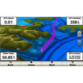
A Garmin exclusive, Auto Guidance 3.0 directs you to your hot spots quickly by instantly creating an on-screen path for your boat to follow that avoids shallow water and other charted obstructions.
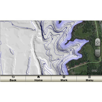
<b>High Resolution Relief Shading (13,000 HD Lakes)</b>
High Resolution Relief Shading adds visual depth to the 2D map making it easier to interpret contours and find fish holding structure.
<b>Dynamic Lake Level (13,000 HD Lakes)</b>
Allows you to adjust your maps to the lake’s current water levels giving you a better idea of spots that are either accessible or too shallow to explore.
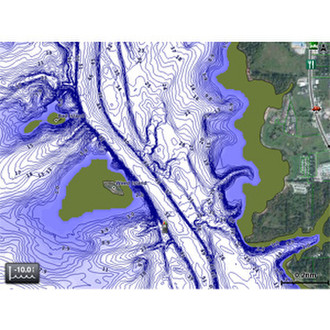
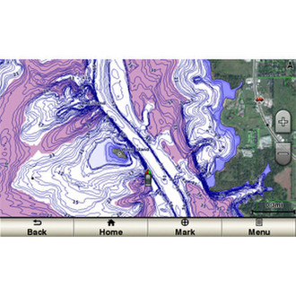
<b>Depth Range Shading (13,000 HD Lakes)</b>
Displays high-resolution Depth Range Shading for up to 10 ranges so you can view your designated target depth. If you know the fish are biting between 10-feet and 15-feet, you can mark that depth range.
<b>FishEye View (13,000 HD Lakes)</b>
Underwater perspective shows 3D representation of lake bottom and contours as seen from below the waterline. Interface with sonar data for customized view.
<b>Mariner'sEye View (13,000 HD Lakes)</b>
Provides a 3D representation of the surrounding area both above and below the waterline.
<b>Sonar Imagery (99 MaxDef Lakes)</b>
Shows a nearly photographic view of the bottom, as if all the water had been drained away.
<b>Surface and Side Scan Photos (99 MaxDef Lakes)</b>
Gives you a clear visual reference of notable spots above and structure below the surface of the water.