内存参数
| 内部存储容量 |
3.7 GB |
| 存储介质类型 |
Flash |
技术细节
| 打猎/鱼日历 |
Y |
| 图片浏览器 |
Y |
| 追踪记录 |
Y |
| 面积的计算方法 |
Y |
| 日月相功能 |
Y |
| 航点 |
Y |
GPS类型
| 自行车 |
Y |
| 露营/营地 |
N |
| 高尔夫球 |
N |
| 摩托车 |
Y |
| 自动 |
Y |
| 户外(登山,远足) |
Y |
| 海洋(图绘图仪,探测器,测距仪鱼) |
Y |
导航
| 实时交通信息频道(TMC) |
N |
| 在线服务 |
N |
| 照片导航 |
Y |
| 自动路由 |
Y |
| 气压高度表 |
Y |
| 电子罗盘 |
Y |
| 航线数量 |
200 |
| 轨道数量 |
200 |
| 交通信息频道(TMC) |
N |
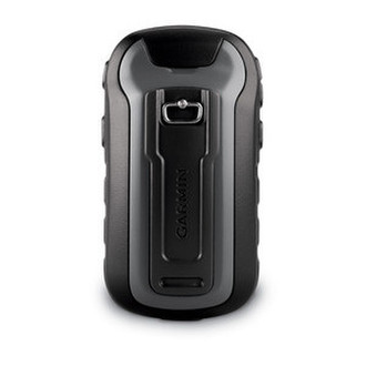
5.588 cm (2.2 ") TFT, 240 x 320 px, microSD, 25 h, 5.4 x 10.3 x 3.3 cm, 141.7 g, World Wide Basemap
<b>Handheld GPS, 3-axis Compass: Better Resolution and Memory</b>
- Greater resolution with 240 x 320 display pixels for improved readability
- Internal memory expanded to hold more maps
- Worldwide basemap with shaded relief
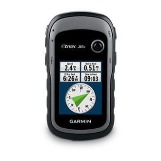
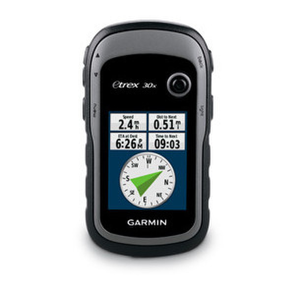
- 2.2-inch, 65K color, sunlight-readable display
- 3-axis compass and barometric altimeter
- eTrex 30x is our upgraded version of the popular eTrex 30, with enhanced screen resolution for a more readable display and internal memory expanded to hold more maps. It retains the ease-of-use, durability and affordability that eTrex is legendary for and can also be used on ATVs, bicycles, boats, cars or hot air balloons.
<b>See the Way</b>
eTrex 30x has an enhanced 2.2-inch, 65K color, sunlight-readable display. Durable and waterproof, eTrex 30x is built to withstand the elements. It has an upgraded interface yet retains its legendary toughness to withstand dust, dirt, humidity or water.
<b>New Tools for Your Trek</b>
eTrex 30x adds a built-in 3-axis tilt-compensated electronic compass, which shows your heading even when you’re standing still, without holding it level. Also added is a barometric altimeter which tracks changes in pressure to pinpoint your precise altitude, and you even can use it to plot barometric pressure over time, which can help you keep an eye on changing weather conditions.
<b>Go Anywhere</b>
With an array of compatible mounts, eTrex 30x is designed as a handheld or for use on ATVs, bicycles, in boats, cars even hot air balloons. Use the auto mount capability and City Navigator NT maps for turn-by-turn driving directions, or the rugged mount for your motorcycle or ATV. Wherever you think you might take eTrex, it has the mapping and mounts to get you there.
<b>Go Global</b>
The eTrex series is the first-ever consumer-grade receivers that can track both GPS and GLONASS satellites simultaneously. When using GLONASS satellites, a system developed by the Russian Federation, the time it takes for the receiver to “lock on” to a position is (on average) approximately 20 percent faster than using GPS. And when using both GPS and GLONASS, the receiver has the ability to lock on to 24 more satellites than using GPS alone.
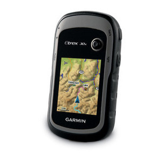
<b>Add Maps</b>
With its microSD card slot and expanded 3.7 GB of internal memory, eTrex 30x lets you load TOPO 24K or Garmin HuntView™ maps and hit the trail, plug in BlueChart g2 preloaded cards for a great day on the water or City Navigator NT map data for turn-by-turn routing on roads. eTrex 30x also supports BirdsEye Satellite Imagery (subscription required), that lets you download satellite images to your device and integrate them with your maps.
<b>Share Wirelessly</b>
Wirelessly connecting to a variety of compatible Garmin devices, including VIRB action cameras and ANT+ sensors (including a heart rate monitor), the eTrex 30x can also read from and write to the chirp wireless beacon — or link with your trail buddy’s Oregon, Montana, GPSMAP 64 or other ANT+-enabled outdoor navigation devices.
<b>
Keep Your Fix</b>
With its high-sensitivity, WAAS-enabled GPS receiver and HotFix satellite prediction, eTrex locates your position quickly and precisely and maintains its GPS location even in heavy cover and deep canyons.
<b>Find Fun</b>
eTrex 30x supports geocaching GPX files for downloading geocaches and details straight to your unit. Visit Geocaching.com to start your geocaching adventure. By going paperless, you're not only helping the environment but also improving efficiency. eTrex 30x stores and displays key information, including location, terrain, difficulty, hints and descriptions, which means no more manually entering coordinates and paper printouts. Simply upload the GPX file to your unit and start hunting for caches.
<b>
Plan Your Next Trip</b>
Take charge of your next adventure with BaseCamp, software that lets you view and organize maps, waypoints, routes, and tracks. This free trip-planning software even allows you to create Garmin Adventures that you can share with friends, family or fellow explorers. BaseCamp displays topographic map data in 2-D or 3-D on your computer screen, including contour lines and elevation profiles. It also can transfer an unlimited amount of satellite images to your device when paired with a BirdsEye Satellite Imagery subscription.