能量控制
| 支持的的电池数量 |
2 |
| 电池寿命(最大值) |
20 h |
| 电池类型 |
AA |
技术细节
| 打猎/鱼日历 |
Y |
| 图片浏览器 |
Y |
| 追踪记录 |
Y |
| 单位对单位转让 |
Y |
| 潮汐表 |
Y |
| 面积的计算方法 |
Y |
| 日月相功能 |
Y |
| 航点 |
Y |
GPS类型
| 卡车 |
N |
| 自动 |
N |
| 户外(登山,远足) |
Y |
| 地理寻宝 (gps寻宝) |
Y |
| 海洋(图绘图仪,探测器,测距仪鱼) |
N |
| 体育(健身,跑 步,骑自行车) |
N |
| 航空 |
N |
导航
| 照片导航 |
Y |
| 自动路由 |
Y |
| 气压高度表 |
Y |
| 电子罗盘 |
Y |
| 航线数量 |
200 |
| 交通信息频道(TMC) |
N |
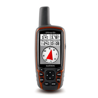
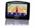
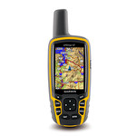
6.604 cm (2.6 ") TFT, 160 x 240, USB & NMEA 0183, 1.7GB, microSD, IPX7, 2 x AA + Topo Deutschland
The newly designed GPSMAP 62s handheld navigator features a 3-axis tilt-compensated compass, a barometric altimeter and supports Custom Maps, BirdsEye™ Satellite imagery (subscription required) and photo navigation. Rugged and waterproof, GPSMAP 62s employs a quad helix antenna for unparalleled reception, has a high-speed USB connection, a sleek new design and connects wirelessly to compatible Garmin handhelds.
<b>Explore</b>
GPSMAP 62s comes with built-in worldwide basemap with shaded relief, so you can navigate anywhere with ease. With photo navigation, you can download pictures from Garmin Connect™ Photos and navigate to them.
<b>Get Your Bearings</b>
GPSMAP 62s has a built-in 3-axis tilt-compensated electronic compass, which shows your heading even when you’re standing still, without holding it level. Its barometric altimeter tracks changes in pressure to pinpoint your precise altitude, and you can even use it to plot barometric pressure over time, which can help you keep an eye on changing weather conditions.
<b>Share Wirelessly</b>
With GPSMAP 62s you can share your waypoints, tracks, routes and geocaches wirelessly with other compatible Garmin device users. So now your friends can also enjoy your favorite hike or cache — simply press “send” to transfer your information to similar units, and let the games begin.
<b>Keep Your Fix</b>
With its quad helix antenna and high-sensitivity, WAAS-enabled GPS receiver and HotFix® satellite prediction, GPSMAP 62s locates your position quickly and precisely and maintains its GPS location even in heavy cover and deep canyons. The advantage is clear — whether you’re in deep woods or just near tall buildings and trees, you can count on GPSMAP 62s to help you find your way when you need it the most.
<b>Add Maps</b>
Adding more maps is easy with Garmin's wide array of detailed topographic, marine and road maps. With 1.7 GB of onboard memory, you can conveniently download 24K and 100K TOPO maps and hit the trail, plug in BlueChart® g2 preloaded cards for a great day on the water or City Navigator NT® map data for turn-by-turn routing on roads (see maps tab for compatible maps). GPSMAP 62s also supports BirdsEye™ Satellite Imagery (subscription required), that lets you download satellite images to your device and integrate them with your maps. In addition, the 62s is compatible with Custom Maps, free software that transforms paper and electronic maps into downloadable maps for your device.
<b>Get Connected</b>
You've been busy exploring and now you want to store and analyze your activities. With a simple connection to your computer and to the Internet, you can get a detailed analysis of your activities and send tracks to your outdoor device using Garmin Connect™. This one-stop site offers an activity table and allows you to view your activities on a map using Google™ Earth. Explore other routes uploaded by millions of Garmin Connect users and share your experiences on Twitter® and Facebook®. Getting started is easy, so get out there, explore, and share.
<b>Find Fun</b>
GPSMAP 62s supports geocaching GPX files for downloading geocaches and details straight to your unit. By going paperless, you're not only helping the environment but also improving efficiency. GPSMAP 62s stores and displays key information, including location, terrain, difficulty, hints and descriptions, which means no more manually entering coordinates and paper print outs! Simply upload the GPX file to your unit and start hunting for caches. Slim and lightweight, 62s is the perfect companion for all your outdoor pursuits.