导航
| 航线数量 |
200 |
| 气压高度表 |
N |
| 电子罗盘 |
N |
| 自动路由 |
Y |
| 照片导航 |
Y |
技术细节
| 日月相功能 |
Y |
| 面积的计算方法 |
Y |
| 潮汐表 |
Y |
| 单位对单位转让 |
N |
| 图片浏览器 |
N |
| 打猎/鱼日历 |
Y |
GPS类型
| 自动 |
N |
| 体育(健身,跑 步,骑自行车) |
N |
| 户外(登山,远足) |
N |
| 海洋(图绘图仪,探测器,测距仪鱼) |
Y |
| 地理寻宝 (gps寻宝) |
Y |
| 航空 |
N |
其他功能
| 基本图 |
Y |
| 接口 |
NMEA 0183, USB |
| 内置存储器 |
1724 MB |
能量控制
| 电池寿命(最大值) |
20 h |
| 电池类型 |
AA |
| 支持的的电池数量 |
2 |
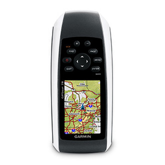
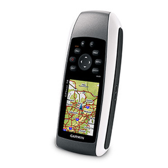
010-00864-00 - GPSMAP 78, 6.604 cm (2.6 ") TFT, 160 x 240, 2 AA, IPX7, USB and NMEA 0183, 1.7 GB, microSD
For boaters and watersports enthusiasts who want to run with the best, the rugged GPSMAP 78 features crisp colour mapping, high-sensitivity receiver, new moulded rubber side grips, plus a microSD™ card slot for loading additional maps. And it floats!
Explore
GPSMAP 78 comes with built-in worldwide basemap, so you can navigate anywhere with ease. And, like the rest of the 78-series, the 78 is IPX7 waterproof and even floats in water.
Keep Your Fix
With its high-sensitivity, WAAS-enabled GPS receiver and HotFix™ satellite prediction, GPSMAP 78 locates your position quickly and precisely and maintains its GPS location even in heavy cover and built-up areas. The advantage is clear — whether you’re in dense woodland or just near tall buildings and trees, you can count on GPSMAP 78 to help you find your way when you need it the most.
Add Maps
Adding more maps is easy with Garmin's wide array of detailed marine, topographic and road maps, available on microSD card. Conveniently plug in BlueChart® g2 preloaded cards for a great day on the water or City Navigator NT® map data for turn-by-turn routing by road (see maps tab for compatible maps). The card slot is located inside the waterproof battery compartment, so you don't have to worry about getting it wet. GPSMAP 78 also supports BirdsEye™ Satellite Imagery (subscription required), that lets you download satellite images to your device and integrate them with your maps. In addition, the 78 is compatible with Custom Maps, free Garmin software that transforms your own paper and electronic maps into downloadable maps for your GPS handheld device.
Get Connected
You've been busy exploring and now you want to store and analyse your activities. With a simple connection to your computer and to the Internet, you can get a detailed analysis of your activities and send tracks to your outdoor device using Garmin Connect™. This one-stop site offers an activity table and allows you to view your activities on a map using Google™ Earth. Explore other routes uploaded by millions of other Garmin Connect users and share your experiences on Twitter® and Facebook®. Getting started is easy, so get out there, explore, and share.
Find Fun
GPSMAP 78 supports geocaching GPX files for downloading geocaches and details straight to your unit. By going paperless, you're not only helping the environment but also improving efficiency. GPSMAP 78 stores and displays key information, including location, terrain, difficulty, hints and descriptions, which means no more manually entering coordinates and paper print outs! Simply upload the GPX file to your unit and start hunting for caches. Slim and lightweight, 78 is the perfect companion for all your outdoor pursuits.