产品特点
| 区域定位 |
North America |
| 阴影深度轮廓 |
Y |
| 用户数量 |
1 user(s) |
| 覆盖详情 |
Inland Rivers |
| 卫星空照影像 |
Y |
| 自动导航技术 |
Y |
| 航拍照片 |
Y |
系统要求
| 最低内存 |
1024 MB |
| 需要互联网连接 |
Y |
| USB需求 |
Y |
VUS036R - Inland Rivers, microSD/SD
See your vessel’s precise, on-chart position in relation to navaids, coastal features and restricted areas with premium features found in this detailed marine mapping data. Includes all of the features of our BlueChart® g2 product, plus 3-D perspective above and below the waterline, Auto Guidance, high-resolution imagery, and aerial photos of ports, harbors, marinas and landmarks.
- Shaded depth contours, coastlines, spot soundings, navaids, port plans, wrecks, obstructions, intertidal zones, restricted areas and IALA symbols.
- Seamless transitions between zoom levels and more continuity across chart boundaries.
- High resolution satellite imagery for a realistic view of the land and water.
- Aerial photos of ports, harbors, marinas, waterways, navigational landmarks and other POIs.
- Auto Guidance technology searches chart data to suggest the best passage to a destination.
- MarinerEye view 3-D perspective for a quick, easy position fix.
- FishEye view 3-D perspective for an underwater view of the sea floor.
- Safety Shading* enables contour shading for all depth contours shallower than your defined safe depths.
- Fishing Charts* to scope out bottom contours and depth soundings with less visual clutter on the display.
- Plan and organize routes from your computer with HomePort™.
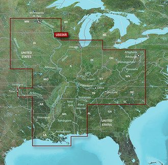
<b>Coverage</b>
Detailed main channel coverage of the major rivers of the interior of the United States as part of the Great Circle Route. Coverage includes the Ohio, Illinois, Tombigbee, Black Warrior, and Atchafalaya Rivers in their entirety, as well as the Tenn-Tom Waterway in full. Coverage also features the Mississippi River from its junction with the Minnesota River above Minneapolis-St. Paul, MN to the Delta; the Missouri River from St Louis, MO to Sioux City, IA; the Tennessee River from Knoxville, TN to the Ohio; the Cumberland River from Celina, TN to the Ohio; the Allegheny River from East Brady, PA to the Ohio; the Monongahela River from Fairmont, WV to the Ohio; the Kanawha River from Montgomery, WV to the Ohio; the Green River from Rochester, KY to the Ohio; the Verdigris River from the Port of Catoosa to the Arkansas; the Arkansas River from its junction with the Verdigris River outside of Tulsa, OK to the Mississippi; and the Red River from Shreveport, LA to the Mississippi. General coverage of the Gulf of Mexico from Port Arthur, TX to Pensacola, FL and the southern portion of Lake Michigan from Waukegan, IL to South Haven, MI.