技术细节
| 打猎/鱼日历 |
Y |
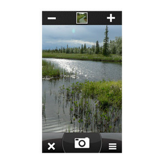
| 图片浏览器 |
Y |
| 单位对单位转让 |
Y |
| 潮汐表 |
Y |
| 面积的计算方法 |
Y |
| 日月相功能 |
Y |
导航
| 在线服务 |
N |
| 照片导航 |
Y |
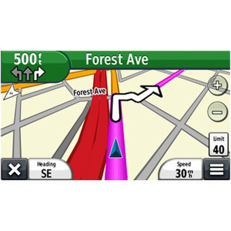
| 自动路由 |
Y |
| 气压高度表 |
Y |
| 电子罗盘 |
Y |
| 航线数量 |
200 |
| 交通信息频道(TMC) |
N |
GPS类型
| 自动 |
N |
| 户外(登山,远足) |
Y |
| 地理寻宝 (gps寻宝) |
Y |
| 海洋(图绘图仪,探测器,测距仪鱼) |
N |
| 体育(健身,跑 步,骑自行车) |
N |
| 航空 |
N |
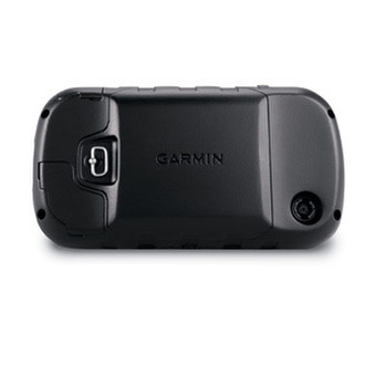
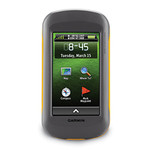
Montana 650 - 4" TFT 272 x 480 touchscreen, 3.0 GB, microSD, 5MP Camera, USB, 289 g.
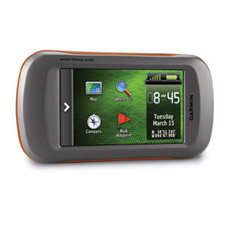
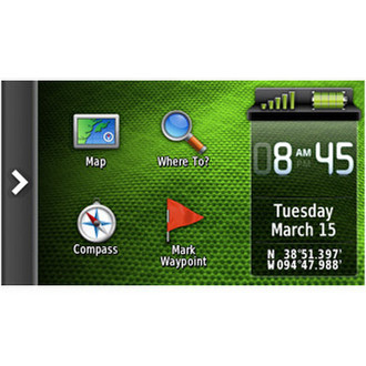
Take it hiking. Take it hunting. Take it on the water. Montana 650 features a bold 4 in. color touchscreen dual orientation display and supports multiple mapping options like BirdsEye™ Satellite Imagery and it has a 5 megapixel camera to boot. Montana has key features for the outdoors such as a 3-axis tilt-compensated compass and barometric altimeter. Buy the auto mount and a City Navigator NT® map and it'll give you spoken turn-by-turn driving directions. It's big. It's versatile. It's tough. It earned the name Montana - the ultimate in touchscreen toughness.
<b>See the Big View</b>
Montana 650 features a vast 4 in., sunlight-readable touchscreen display that offers crystal clear enhanced colors and displays high-resolution images. It’s easy-to-use interface means you’ll spend more time enjoying the outdoors and less time searching for information. Both durable and waterproof, Montana 650 is built to withstand the elements. Bumps, dust, dirt, humidity and water are no match for this rugged navigator. No matter the setting – on the boat, in the RV or on an ATV – Montana is right at home.
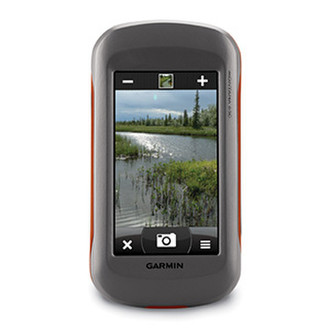
<b>Take Geotagged Pictures</b>
Capture locations and memories with Montana 650’s 5 megapixel digital camera. Each photo is geotagged automatically with the location of where it was taken, allowing you to navigate back to that exact spot in the future. Snap and view pictures in landscape or portrait orientation. To keep track of your photos and show their location on a map, simply connect Montana 650 via USB and use Garmin’s free BaseCamp software. For more storage, insert a microSD™ card; you can even view pictures from other devices on microSD with Montana's picture viewer.
<b>Go Anywhere</b>
With an array of compatible mounts, Montana 650 is designed for use on ATV’s, in boats, as a handheld or in your car as a personal navigator. Use the auto mount with City Navigator maps for spoken, turn-by-turn driving directions, or the rugged mount for your motorcycle or ATV. Wherever you think you might take Montana, it has the mapping and mounts to get you there.
<b>Go Everywhere</b>
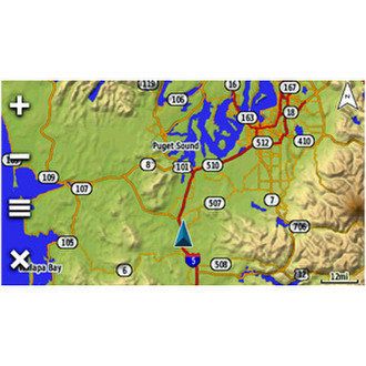
Adding more maps is easy with Garmin's wide array of detailed topographic, marine and road maps. With its microSD™ card slot, Montana 650 lets you load TOPO U.S. 24K maps and hit the trail, plug in BlueChart® g2 preloaded cards for a great day on the water or City Navigator map data for turn-by-turn routing on roads (see maps tab for compatible maps). Montana 650 also supports BirdsEye Satellite Imagery (subscription required), that lets you download satellite images to your device and integrate them with your maps. In addition, Montana is compatible with Custom Maps, free software that transforms paper and electronic maps into downloadable maps for your device.
<b>Share Wirelessly</b>
With Montana 650 you can share your waypoints, tracks, routes and geocaches wirelessly with other compatible Garmin GPS users. So now your friends also can enjoy your favorite hike or cache – simply press “send” to transfer your information to similar units, and let the games begin.
<b>Keep Your Fix</b>
With its high-sensitivity, WAAS-enabled GPS receiver and HotFix® satellite prediction, Montana 650 locates your position quickly and precisely and maintains its GPS location even in heavy cover and deep canyons. The advantage is clear — whether you’re in deep woods or just near tall buildings and trees, you can count on Montana 650 to help you find your way when you need it the most.
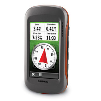
<b>Navigate with Ease</b>
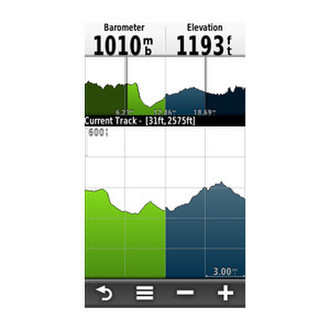
Montana 650 has a built-in 3-axis tilt-compensated electronic compass, which shows your heading even when you’re standing still, without holding it level. Its barometric altimeter tracks changes in pressure to pinpoint your precise altitude, and you even can use it to plot barometric pressure over time, which can help you keep an eye on changing weather conditions.
<b>Double Your Power</b>
Montana 650 features a one-of-a-kind dual battery system. You’ll have the option of using the rechargeable lithium-ion pack or traditional AA batteries – whichever suits your needs better.
<b>Find Fun</b>
Montana 650 supports geocaching GPX files for downloading geocaches and details straight to your unit. Visit OpenCaching.com to start your geocaching adventure. By going paperless, you're not only helping the environment but also improving efficiency. Montana 650 stores and displays key information, including location, terrain, difficulty, hints and descriptions, which means no more manually entering coordinates and paper print outs! Simply upload the GPX file to your unit and start hunting for caches.