技术细节
| 航点 |
Y |
| 日月相功能 |
Y |
| 面积的计算方法 |
Y |
| 追踪记录 |
Y |
| 图片浏览器 |
Y |
| 打猎/鱼日历 |
Y |
| 国际保护(IP)代码 |
IPX7 |
导航
| 轨道数量 |
200 |
| 航线数量 |
200 |
| 气压高度表 |
Y |
| 电子罗盘 |
Y |
| 自动路由 |
Y |
| 兴趣点 |
10000 |
GPS类型
| 自动 |
Y |
| 摩托车 |
Y |
| 户外(登山,远足) |
Y |
| 地理寻宝 (gps寻宝) |
Y |
| 自行车 |
Y |
能量控制
| 电池技术 |
Lithium-Ion (Li-Ion) |
| 电池寿命(最大值) |
16 h |
| 电源类型 |
Battery |
内存参数
| 兼容性内存条 |
MicroSD (TransFlash) |
| 内部存储容量 |
2.7 GB |
| 存储介质类型 |
Flash |
重量和尺寸
| 深度 |
36.4 mm |
| 宽度 |
74.8 mm |
| 重量 |
289 g |
| 高度 |
144.2 mm |
另外
| 显示器的颜色数量 |
65536 colours |
| 产品色彩 |
Black |
| 导航点/喜爱点数量 |
4000 |
| 包括 AC 适配器 |
Y |
IPX7, 289 g, 10.16 cm (4 ") , TFT, 272 x 480, 2.7 GB, 74.8 x 144.2 x 36.4 mm, microSD
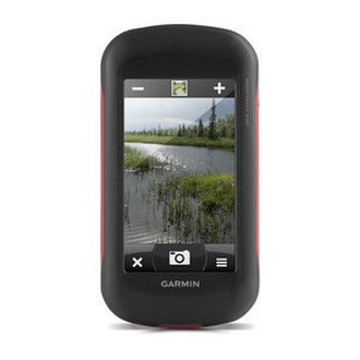
The handheld GPS to go anywhere and everywhere
- NEW GPS and GLONASS – faster and better satellite fix
- 4" outdoor optimised, dual orientation display – best visibility on Garmin's largest handheld display, for easy readability under any condition
- NEW Comes with great content preinstalled – 250k geocaches from Geocaching.com and 1 year free BirdsEye Satellite Imagery1
- NEW Adds new Track Manager for better user experience and more control
- NEW 8MP camera – for high resolution geotagged pictures
- Most versatile navigation everywhere – most versatile features, display and mounting
- Barometric altimeter and 3-axis compass
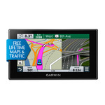
Designed for use on the trail, on road or on the water, the Montana 680 from Garmin will guide you wherever you go. With a vast 4” sunlight-readable touchscreen that offers crystal clear enhanced colours, dual orientation display and GPS and GLONASS positioning to track your location quicker and more accurately, even in the most challenging environment. It’s easy to see where you are at all times and conveniently control your track recording with the new Track Manager. Montana 680 includes a 3-axis electronic compass with barometric altimeter and comes with a free 1-year BirdsEye Satellite Imagery subscription1. Both durable and waterproof, Montana 680 adds a 8MP camera and is built to withstand the elements.
See the Big View
Montana 680 features a 4" outdoor optimised, dual orientation touchscreen display that offers best readability under any light condition. The easy-to-use touch screen user interface means you’ll spend more time enjoying the outdoors and less time searching for information. Adventurers love the extra-large display of Montana that provides great readability due to big data fields and clearly visible map features. Both durable and water resistant, Montana 680 is built to withstand the elements. Bumps, dust, dirt, humidity and water are no match for this rugged navigator2.
Take Geotagged Pictures
Capture locations and memories with Montana 680's upgraded 8 megapixel digital camera. Each photo is geotagged automatically with the location of where it was taken, allowing you to navigate back to that exact spot in the future. Snap and view pictures in landscape or portrait orientation. Keep track of your photos and see their locations on a map using BaseCamp™. Insert a microSD card for more photo storage or to view pictures from other devices.
Keep Your Fix
With the new high-sensitivity GPS and GLONASS receiver, Montana 680 locates your position quickly and precisely and maintains its location even in thick forest and deep valleys. The advantage is clear — whether you’re under heavy tree cover or just near tall buildings and trees, you can count on Montana 680 to help you find your way when you need it the most.
Go Anywhere
With an array of compatible mounts, Montana is designed for use on bicycles, in 4x4s, on boats and as a handheld or for convenient everyday navigation in your car. Use the optional auto mount with City Navigator maps for spoken, turn-by-turn driving directions, or try out the optional rugged mount for your motorcycle or ATV.
Go Everywhere
Montana 680 comes with an 1-year BirdsEye Satellite Imagery subscription for great aerial images to enhance your navigation, in case you want more detailed information adding more maps to Montana is easy1. Load TOPO maps and hit the trail, plug in BlueChart® g2 preloaded cards for a great day on the water, or load City Navigator map data for turn-by-turn driving directions. Or, transform paper maps into files you can download to your Montana with Custom Maps.
Navigate with Ease
The new Montana 680 features a Track Manager app that allows you to record, view and analyse your tracks in a very convenient and intuitive way. The handheld has key features for the outdoors such as a 3-axis tilt-compensated compass which shows your heading even when you’re still, without holding it level. It also has a barometric altimeter which tracks changes in pressure to pinpoint your precise altitude, and you can even use it to plot barometric pressure over time, which can help you keep an eye on changing weather conditions.
Find Fun
Montana 680 comes preloaded with 250,000+ assorted geocaches from geocaching.com and supports paperless geocaching. This allows Montana 680 to store and displays key cache information, including location, terrain, difficulty, hints and descriptions, which means no more manually entering coordinates and paper print outs. Once you want to add more caches simply upload the GPX file to your device and keep the hunt going.
Share Wirelessly
With Montana 680 you can share your waypoints, tracks, routes and geocaches wirelessly with other compatible Garmin GPS users. Simply press “Send” to transfer your information to other units.
Double Your Power
Montana 680 features the Garmin dual battery system that guarantees a maximum of independence. You’ll have the option of using the rechargeable lithium-ion battery pack or traditional AA alkaline batteries – whichever suits you best.
Plan Your Next Trip
Take charge of your next adventure with our free BaseCamp™, software that lets you view and organise maps, waypoints, routes, and tracks. This free trip-planning software even allows you to create Garmin Adventures that you can share with friends, family or fellow explorers. BaseCamp displays topographic map data in 2-D or 3-D on your computer screen, including contour lines and elevation profiles. It also can transfer an almost unlimited amount of satellite images to your device from the included BirdsEye Satellite Imagery subscription.
The Montana is the ultimate take-anywhere navigator for the serious adventurer.