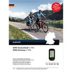
Topo Benelux
Preparing for that great outdoor adventure? TOPO BeNeLux is the perfect outdoor companion for recreation and outdoor activities covering Belgium, the Netherlands and Luxembourg on the same disk. The data for TOPO BeNeLux has been collated from the various local national geographic services for these three countries and are generated from maps of 1:50,000 scale; however, for some regions in the Netherlands the detail reaches the 1:10,000 map scale. TOPO BeNeLux includes roads and paths, points of interest, land usage and height contour lines. Itinerary vertical profile can be displayed in MapSource® or on compatible Garmin devices.
TOPO BeNeLux is intended for use in Europe. All content and map data is available in French and Dutch. The user manual is also available in English.