TOPO U.S. Mid-Atlantic, 1:100000, microSD/SD
Get More Detail
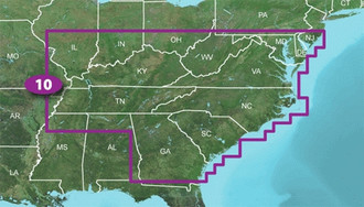
We've mapped every hill and valley for your next great adventure. TOPO U.S. 100K – Mid-Atlantic covers the finer points of the outdoors, with topographic maps comparable to 1:100,000 scale USGS maps. TOPO U.S. includes terrain contours, topo elevations, summits, parks, coastlines, rivers, lakes and geographical points. TOPO maps are ideal for hiking, hunting, camping, cycling and communing with nature. Coverage includes topographic detail of the Atlantic Coast from Savannah, GA, to Atlantic City, NJ, as well as Kentucky, Virginia, North and South Carolina, Tennessee and most of Georgia and West Virginia.
- Includes topographic coverage of the Atlantic Coast from Savannah, GA, to Atlantic City, NJ, as well as Kentucky, Virginia, North and South Carolina, Tennessee and most of Georgia and West Virginia.
- Provides detailed digital topographic maps, comparable to 1:100,000 scale USGS maps.
- Contains summit locations with elevation, coastlines, lake and river shorelines, wetlands and perennial and seasonal streams.
- Allows you to search by city, geographic point, summit, lakes and more.
- Provides elevation profile on compatible Garmin devices so you can estimate terrain difficulty.
- Contains many routable trails, rural roads, city neighborhood roads, major highways and interstates.
- Displays national, state and local parks, forests and wilderness areas.
- Includes points of interests such as parks, campgrounds, scenic lookouts and picnic sites.