产品特点
| 区域定位 |
West Africa |
| 用户数量 |
1 user(s) |
| 覆盖详情 |
Western Africa |
系统要求
| USB需求 |
Y |
| 最低内存 |
1024 MB |
| 需要互联网连接 |
Y |
| 最小硬盘空间 |
0.313 GB |
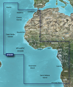
HAF003R - Western Africa, microSD/SD
See your vessel’s precise, on-chart position in relation to navaids, coastal features, anchorages, obstructions, waterways, restricted areas and more with this detailed marine mapping data.
- Shaded depth contours, coastlines, spot soundings, navaids, port plans, wrecks, obstructions, intertidal zones, restricted areas and IALA symbols.
- Seamless transitions between zoom levels and more continuity across chart boundaries.
- Standard 2-D direct overhead or 3-D “over the bow” map perspective for easy chart reading and orientation.
- Safety Shading* enables contour shading for all depth contours shallower than your defined safe depths.
- Fishing Charts* to scope out bottom contours and depth soundings with less visual clutter on the display.
- Plan and organize routes from your computer with HomePort™.
<b>Coverage</b>
General coverage of the west coast of Africa from El Aaraich, Mor. to Cape Cross, Nam., including Abidjan, C.I., Douala, Cam. and Luanda, Ang. Included in this overall general coverage are a number of detailed charts covering areas such as Casablanca, Mor., Dakar, Sen., and Lagos, Nig. Also includes general coverage of St. Helena Is., Ascension Is., and the Azores. Also includes detailed coverage of the Madeira Islands, Canary Islands, and Cape Verde Islands.