能量控制
| 支持的的电池数量 |
2 |
| 电池类型 |
AA |
| 电池寿命(最大值) |
18 h |
内存参数
| 内部存储容量 |
0.5 GB |
| 存储介质类型 |
Flash |
GPS类型
| 户外(登山,远足) |
Y |
| 自行车 |
N |
| 露营/营地 |
N |
| 卡车 |
N |
| 地理寻宝 (gps寻宝) |
Y |
| 海洋(图绘图仪,探测器,测距仪鱼) |
N |
| 自动 |
N |
| 体育(健身,跑 步,骑自行车) |
Y |
| 航空 |
N |
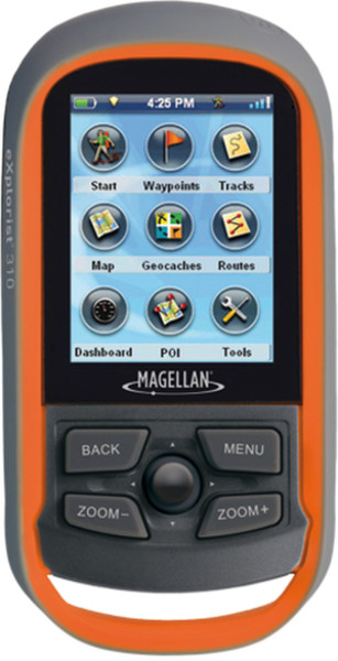
WAAS/EGNOS/MSAS, 3-5m acc, CPU 400MHz, 500 MB, 5.588 cm (2.2 ") LCD (240x320), USB, 147 g, Orange/Grey
Waterproof handheld GPS receiver with core outdoor navigation features, expandable mapping, and paperless geocaching
The Magellan eXplorist 310 GPS receiver comes packed with tons of helpful features and is ready to use right out of the box.
The pre-loaded World Edition map includes a complete road network in the United States, Canada, Western Europe, and Australia and major roads throughout the rest of the world. This unique map also includes water features, urban and rural land use, and city centres. Regional versions of Magellan’s Summit Series topographic maps are available for download to expand mapping coverage and level of detail.
A vibrant, transfl ective colour screen allows for the best readability in direct sunlight. To zero in on the exact location of a geocache, favourite fi shing spot, or the next summit, the SiRFstarIII GPS chipset provides accuracy of 10-15 feet (3-5 metres). To keep your outdoor adventure going all day long, the device is powered by two AA batteries for 18 hours of constant usage. The eXplorist 310 is rugged, waterproof, and submersible (IPX-7). All of this is packed into a small and attractive handheld form factor that can be hung around your neck with the optional eXplorist lanyard or attached to your pack with the built-in carabineer hook.
The eXplorist 310 provides unmatched assistance with navigation, such as the combination of the world’s two most useful navigational tools - a compass and a map! Overlay a series of different transparent compass styles on top of the World Edition map. Access the dashboard screen that shows a mini-compass for quick reference and customizable navigation data fi elds, such as latitude, longitude, heading, bearing, distance to end, trip odometer, and many more. Go back to the map screen and view your active track, which is a series of digital breadcrumbs to record all yours movements. Mark your starting point (car, trailhead, parking lot, etc.) with a waypoint and easily navigate back to that location at the end of the day.
The eXplorist 310 supports paperless geocaching, which allows you to download more than 20 unique characteristics of each cache, including name, location, description, hider, size, diffi culty, terrain, hint, spoilers, attributes, and last 20 user logs among a number of other details.
Reference your track summary to keep track of your distance travelled, elevation gained or lost, complete travel time, moving time and stopped time, and average time to fi nd. Easily reset your track summary statistics to track the details of your next outdoor adventure.
No matter where you enjoy the outdoors, the eXplorist 310 GPS receiver will provide precise GPS signals thanks to the Satellite Based Augmentation Systems (SBAS) of WAAS, EGNOS, and MSAS; display coordinates in a myriad of different global systems, including UTM and WGS84; and accurately guide you to and from your next adventure, where ever in the world that may be!