目錄的
-
目錄的
- Antiquitäten & Kunst
- Auto & Motorrad: Fahrzeuge
- Baby
- Bücher
- Camping & Outdoor
- Feinschmecker
- Haustierbedarf
- Heimwerken & Garten
- IT和电子
- Kleidung & Accessoires
- Modellbau
- Musik
- PC- & Videospiele
- Sammeln & Seltenes
- Spielzeug
- TV, Video, DVD
- Telekommunikation
- Uhren & Schmuck
- Wellness & Beauty
- fashion & lifestyle
- institutional food services equipment
- medical equipment, accessories & supplies
- 个人护理
- 休闲爱好
- 办公设备,用品和配件
- 商业与工业
- 家居,建筑,装修
- 家用电器
- 摩托车及配件
- 武器和弹药
- 照相机
- 花园和庭院
- 运动,娱乐及休闲
- 食物
- 高保真音響
Filters
Search
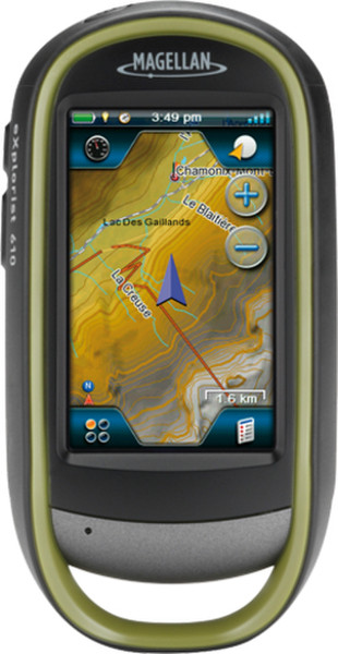
Magellan eXplorist 610 Handheld 3" Touchscreen 195g
凡购买和价格 (Advertising *)
顶部
技术特点
顶部
能量控制
| 支持的的电池数量 | 2 |
|---|---|
| 电池类型 | AA |
| 电池寿命(最大值) | 16 h |
指示灯
| 发声警报器 | Y |
|---|
内存参数
| 记忆卡容量 | 2 GB |
|---|---|
| 存储介质类型 | Flash |
照相机
| 内置摄像头 | Y |
|---|---|
| 像素 | 3.2 MP |
其他功能
| 天线类型 | Multidirectional Patch |
|---|
技术细节
| 内置麦克风 | Y |
|---|---|
| 图片浏览器 | Y |
| 日月相功能 | Y |
| 计算器 | Y |
| 航点 | Y |
处理器
| 处理器频率 | 400 MHz |
|---|
地图
| 地图视图选项 | 2D |
|---|---|
| 地图 | Y |
GPS性能
| GPRS精度-位置 | 5 m |
|---|---|
| 天线 | Y |
导航
| 轨道数量 | 1 |
|---|---|
| 交通信息频道(TMC) | N |
设计
| 格式要素 | Handheld |
|---|
联网
| 蓝牙 | N |
|---|
GPS类型
| 地理寻宝 (gps寻宝) | Y |
|---|
另外
| 导航点/喜爱点数量 | 500 |
|---|
eXplorist 610, 3.2MP, 195g, 7.62 cm (3.0 ") , Touch Screen, microSD
Rugged and waterproof (IPX-7), the eXplorist 610 combines high sensitivity GPS reception with easy to read mapping and accurate navigation. Find your way using more than 30 navigational data fields. Create waypoints, record tracks, and route from point to point. The integrated 3.2 mega-pixel camera, microphone, and speaker enable outdoor enthusiasts to record geo-referenced images and voice notes. Relive your outdoor adventures on the device, on your computer, or share with others on various online communities like geocaching.com.
Enjoy paperless geocaching with the eXplorist 610. Download and view more than 20 unique characteristics of each cache and view, search, filter on the device. Details include name, location, description, hider, size, difficulty, terrain, hint, and recent logs created by other geocachers.
The eXplorist 610 packs the most accurate maps into the palm of your hand. The World Edition map allows for 2D or 3D viewing angles. It includes a complete road network in United States, Canada, Western Europe, and Australia and major roads throughout the rest of the world and provides cartographic orientation in almost any location. This unique, preloaded map also includes water features, urban and rural land use, and a realistic shaded relief background. The eXplorist 610 also includes Summit Series USA, a highly detailed topographic map based on 1:24,000 scale source maps. The maps includes contour lines, land use areas, trails, waterway7s and points of interest. Locate the nearest trailhead. Search for the nearest bike shops, fuel stations, or potable water source. Navigate safely in 3D perspective view while knowing the boundaries between private and public lands.
-
支付方式
我们接受:


