Processor
| Processor frequency |
400 MHz |
Navigation
| Speed limits |
Y |
| Routes quantity |
4 |
| Traffic Message Channel (TMC) |
Y |
Other features
| GPS receiver |
SIRF III |
| Basemap |
Y |
| Interface |
Mini USB |
| Internal memory |
4096 MB |
GPS type
| Auto |
Y |
| Sport (fitness, running) |
N |
| Outdoor (hiking, trekking) |
N |
| Marine (chartplotters, sounders) |
N |
| Geocaching (GPS stash hunt) |
N |
| Aviation |
N |
Technical details
| Interface type |
Touch Screen |
File formats
| Image formats supported |
BMP, JPG |
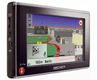
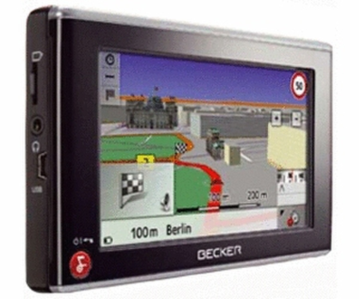
Traffic Assist Z205
Navigation technology that simply gets you from A to B is a thing of the past. Experience the newest generation of mobile navigation systems, and take advantage of their innovative features and customisable flexibility.
Equipped with Bluetooth® wireless technology, the Becker Traffic Assist Z 205 can be configured precisely according to your needs and preferences. Along with its Becker OneShot Speech Dialogue System, the cutting-edge device features POIs enhanced with NAVTEQ Traffic Patterns and free lifetime TMC*, as well as map data for 42 countries.
The mobile navigation system with its appealing Skin Touch design boasts 4 GB of flash memory – providing not only enough space for map data, but also additional features, as well as music and image storage. With the Becker Traffic Assist Z 205, you decide what your navigation system can do.
*Free lifetime TMC (Traffic Master): Traffic report data integrated into route calculations. Improved reception of traffic reports (TMC Pro reports uniquely identified).
Dynamic route guidance with TMC Austria, Belgium, Denmark, Germany, the Netherlands, Spain, Sweden and Switzerland. Access to TMC information without active route guidance. When traffic jam avoidance is possible, an alternative route is displayed for selection.
FREE LIFETIME TMC*
Free lifetime TMC is a traffic holdup warning service. The service provides the latest reports on traffic conditions and hold-ups within Germany, thereby optimizing dynamic route calculation. Free lifetime TMC reports are compiled with current traffic flow data that are automatically recorded with sensors. The data are transmitted to a data centre, where they are analysed and relayed to navigation systems.
BECKER ONESHOT SPEECH DIALOGUE SYSTEM
In addition to entering destinations via the touch screen, the Becker OneShot Speech Dialogue System may also be used. Simply state the destination's address in one sentence and the route calculation begins.
NAVTEQ TRAFFIC PATTERNS
Accumulated traffic data are included in route calculations, enabling the device to determine optimal routes according to the day of the week and time of day. Frequently jammed roads and junctions are thereby avoided.
3D TOWN VIEW
While driving through towns and cities, buildings and streets of houses are represented in 3D along your route, showing you in Map View the scenery you are currently driving past. This presentation of buildings along the route makes orientation easier in urban settings.
3D TERRAIN VIEW
During your journey, the landscape you are driving through will be displayed in 3D. This provides prior notice of approaching ascents and descents or winding roads, allowing you to prepare for on-coming driving demands.
BLUETOOTH® WIRELESS TECHNOLOGY
The Bluetooth® interface is designed for connecting Bluetooth®-compatible mobile phones. Telephone numbers and addresses can be directly entered via the touch-screen display or selected from a list of contacts.
TEXT-TO-SPEECH
During your journey, the announcement of street names will be integrated into spoken navigation instructions. This enhancement makes orientation and turning procedures even easier.
TRAFFIC SIGN DISPLAY
While driving on motorways in Europe, traffic signs with place names and directional indicators are dynamically displayed. This feature particularly eases orientation during frequent motorway transfers and at motorway junctions.
CONTENT MANAGER
Using the Content Manager software on your PC, you can customise the configuration of your device, transferring for example preferred map data, voice and game settings directly to the navigation system.
GPS NAVIGATION
The Global Positioning System (GPS) is a satellite-based navigation system developed by the United States Department of Defence. GPS signals accurately determine the position of a receiver within a few metres. Independent of the means of transport, the signal information is continuously scanned to precisely calculate routes and arrival times.
POINTS OF INTEREST
The map data for Europe contains special destinations including airports, hospitals, service stations, hotels, restaurants and stadiums. Miniature icons show points of interest along the selected route.
MOBILE NAVIGATION
Mobile navigation units are easy to install in just a few steps and can be used practically anywhere. A perfect travel companion for added safety and convenience in the car, on a bike or motorcycle.
LANE INFO
The Lane Info function points the way on multi-lane roads and complicated motorway exits. This gives the driver enough time to change lanes as required.
TOUCH SCREEN
All menu items are quick and easy to access via the 4-inch touch-screen display.
MINI-USB PORT
Software updates and downloads may be directly transferred from a PC to the navigation device via the Mini-USB port. The Mini-USB cable also allows charging the device’s batteries from a PC or notebook.
SPEED LIMITS
A graphic image of the current speed limit appears in the display. An acoustic signal warns the driver when the preset level has been exceeded.
DAY/NIGHT MODE
The display brightness can be easily adjusted from day to night mode via the "Settings" menu. This feature ensures optimal readability in changing light conditions, for example, when driving through a long tunnel.