Features
| Region location |
North America |
| Shaded depth contours |
Y |
| Marine points of interest |
Y |
| Map data type |
Vector |
| IALA symbols |
Y |
| Ports plans |
Y |
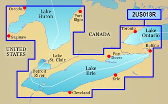
| Coverage details |
Lake Erie-Lake St. Clair |
| 3D above & below waterline |
Y |
| Auto Guidance technology |
Y |
| Aerial photos |
Y |
| Detailed coastal roads |
Y |
| Points of interest |
Y |
Coverage of both the U.S. and Canadian sides of the southern portion of Lake Huron. Detailed coverage of the St. Clair River, Lake St. Clair, Detroit River, and the U.S. portion of Lake Erie through Buffalo. Also includes coverage of the Canadian portion of Lake Erie and the western side of Lake Ontario, including detailed coverage of Long Point Bay, Welland Canal, the Niagara River, and Toronto.
Enhance your nautical navigation with BlueChart g2 Vision high-precision charting. Garmin’s most detailed digital marine data contains premium mapping features including high-resolution satellite imagery, above and below the waterline 3D perspectives, Auto Guidance technology, aerial photography of ports, harbours, marinas and waterways and coastal roads with points of interest. BlueChart g2 Vision gives mariners greater capabilities on the water, with useful navigation landmarks and marine landscape detail to boost your chartplotting technology.
- AutoGuidance technology to find the best course for navigation
- High-resolution satellite imagery
- Aerial reference photography to provide “real world” photos of ports, harbours, marinas, etc
- Mariner’s Eye View – 3D perspective of chart information for a quick, reliable and easy position fix
- Fish Eye View – 3D perspective below the water line for displaying bottom contours based on bathymetric charting data
- Tidal graphs, current arrows, marine services, coastal roads and points of interest detail
- Land based information - detailed coastal roads up to 5 miles inland (non-routable) and business POIs