System requirements
| USB required |
Y |
| Minimum RAM |
1024 MB |
| Internet connection required |
Y |
| Minimum hard disk space |
1.1 GB |
Features
| Number of users |
1 user(s) |
| Coverage details |
Labrador Coast |
| Region location |
North America |
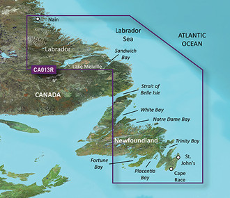
VCA013R - Labrador Coast, microSD/SD
See your vessel’s precise, on-chart position in relation to navaids, coastal features and restricted areas with premium features found in this detailed marine mapping data. Includes all of the features of our BlueChart® g2 product, plus 3-D perspective above and below the waterline, Auto Guidance, high-resolution imagery, and aerial photos of ports, harbors, marinas and landmarks.
- Shaded depth contours, coastlines, spot soundings, navaids, port plans, wrecks, obstructions, intertidal zones, restricted areas and IALA symbols.
- Seamless transitions between zoom levels and more continuity across chart boundaries.
- High resolution satellite imagery for a realistic view of the land and water.
- Aerial photos of ports, harbors, marinas, waterways, navigational landmarks and other POIs.
- Auto Guidance technology searches chart data to suggest the best passage to a destination.
- MarinerEye view 3-D perspective for a quick, easy position fix.
- FishEye view 3-D perspective for an underwater view of the sea floor.
- Safety Shading* enables contour shading for all depth contours shallower than your defined safe depths.
- Fishing Charts* to scope out bottom contours and depth soundings with less visual clutter on the display.
- Plan and organize routes from your computer with HomePort™.
<b>Coverage</b>
Coverage of the eastern and southern coasts of New Foundland from St. Barbe in the Strait of Belle Isle to Hermitage Bay, including Bonavista and St. John's. Also covers the Labrador Coast from Forteau Bay to Nain Bay, including Lake Melville.