System requirements
| USB required |
Y |
| Minimum hard disk space |
1.2 GB |
| Minimum RAM |
1024 MB |
| Internet connection required |
Y |
Features
| Region location |
North America |
| Number of users |
1 user(s) |
| Coverage details |
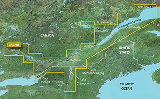
St. Lawrence Seaway |
VUS020R - St. Lawrence Seaway, microSD/SD
See your vessel’s precise, on-chart position in relation to navaids, coastal features and restricted areas with premium features found in this detailed marine mapping data. Includes all of the features of our BlueChart® g2 product, plus 3-D perspective above and below the waterline, Auto Guidance, high-resolution imagery, and aerial photos of ports, harbors, marinas and landmarks.
- Shaded depth contours, coastlines, spot soundings, navaids, port plans, wrecks, obstructions, intertidal zones, restricted areas and IALA symbols.
- Seamless transitions between zoom levels and more continuity across chart boundaries.
- High resolution satellite imagery for a realistic view of the land and water.
- Aerial photos of ports, harbors, marinas, waterways, navigational landmarks and other POIs.
- Auto Guidance technology searches chart data to suggest the best passage to a destination.
- MarinerEye view 3-D perspective for a quick, easy position fix.
- FishEye view 3-D perspective for an underwater view of the sea floor.
- Safety Shading* enables contour shading for all depth contours shallower than your defined safe depths.
- Fishing Charts* to scope out bottom contours and depth soundings with less visual clutter on the display.
- Plan and organize routes from your computer with HomePort™ (sold separately).
<b>Coverage</b>
Covers the St. Lawrence River from Brockville, ON. to Sept-Îles, QC., including Montreal and Quebec. Also includes detailed coverage of Lake Champlain and Lac Saint-Jean, including Burlington, VT, Lac Memphémagog, Rideau River, the Ottawa River to Temiscaming, the Riviere Saguenay from Chicoutimi, QC. to the St. Lawrence River, and the Hudson River to Troy, NY.